


US Topo Maps
ATLOGIS Geoinformatics oHGDescriere US Topo Maps
Aplicație de navigare în aer liber ușor de utilizat, cu acces gratuit la cele mai bune hărți și imagini aeriene disponibile pentru SUA.
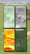
Alegeți între peste 30 de straturi de hărți (topos, antene, hărți maritime, ...) pentru a planifica călătoria perfectă și
Transformă-ți telefonul/tableta Andoid într-un GPS în aer liber pentru excursii offline în backcountry.
Adăugați cu ușurință hărți din alte surse (GeoPDF, GeoTiff, servicii de hărți online precum WMS, ...)
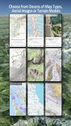
Straturi de hartă de bază disponibile pentru SUA:
• USGS National Map Topo
• USGS National Map Imagery Topo
• Imagini de hartă națională USGS
• Imagini USGS NAIP HiRes
• USGS Topo DRG tradiționale: Acoperire fără întreruperi a hărților topografice ale SUA la scara 1:250.000, 1:100.000, 1:63.000 și 1:24.000/25.000
• Hărți FSTopo Forest
• Diagrame RNC nautice NOAA
• Hărți naționale de altitudine (Hillshade, Harta de pante, Hartă de aspect)
Straturi de hartă de bază la nivel mondial:
• OpenStreetMaps (5 machete diferite de hărți), de asemenea, descărcabile în format vectorial pentru economisirea spațiului
• Google Maps (imagini din satelit, hartă rutieră și teren)
• Hărți Bing (imagini din satelit, Hartă rutieră)
• Pământul Noaptea
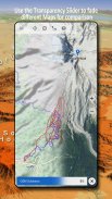
Configurați un strat de hartă de bază ca suprapunere și utilizați un fader de transparență pentru a compara perfect hărțile între ele.
Adăugați hărți din alte surse:
• Importați hărți raster în GeoPDF, GeoTiff, MBTiles sau Ozi (Oziexplorer OZF2 și OZF3)
• Adăugați servicii de cartografiere web ca WMS sau WMTS/Tileserver
• Importați OpenStreetMaps în format Vector, de exemplu complet SUA pentru doar câțiva GB
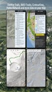
Suprapuneri disponibile pentru hărți din SUA - adăugați informații suplimentare la orice altă hartă de bază:
• Proprietatea publică a terenurilor (PAD-US 3)
• Setul de date hidrografice naționale
• Harta de utilizare a vehiculelor cu motor (USDA)
• Contururi de cotă
• Trasee 4WD
• Trasee
• Drumuri, căi ferate, aeroporturi
Suprapuneri disponibile la nivel mondial:
• Suprapunere Hillshading
• 20m Contururi
• OpenSeaMap
Nu există o hartă perfectă. Comutați între diferitele straturi ale hărții sau utilizați funcția de comparare a hărților pentru a găsi traseul cel mai interesant. În special, vechile DRG-uri tradiționale conțin multe căi mici sau alte caracteristici care lipsesc pe hărțile moderne.
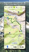
Caracteristici principale pentru navigarea în aer liber:
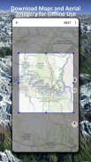
• Descărcați datele hărții pentru UTILIZARE OFFLINE
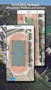
• Măsurați căile și zonele
• Creați și editați puncte de referință
• GoTo-Waypoint-Navigation
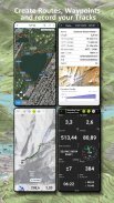
• Creați și editați rute
• Navigare rută (navigație punct la punct)
• Înregistrare piese (cu profil de viteză, altitudine și precizie)
• Tripmaster cu câmpuri pentru odometru, viteză medie, direcție, cotă etc.
• Import/Export GPX/KML/KMZ
• Căutare (nume de locuri, POI, străzi)
• Obțineți altitudine și distanță
• Câmpuri de date personalizabile în Hartă View și Tripmaster (de exemplu, Viteză, Distanță, Busolă, ...)
• Partajați puncte de referință, trasee sau rute (prin e-mail, Dropbox, WhatsApp, ..)
• Folosiți coordonatele în WGS84, UTM sau MGRS/USNG (Grilă militară/ Grilă națională a SUA),
• Reluare a piesei
• si multe altele ...
Utilizați această aplicație de navigare pentru activități în aer liber, cum ar fi drumeții, ciclism, camping, alpinism, călărie, schi, canotaj, vânătoare, tururi cu snowmobilul, tururi offroad 4WD sau căutare și salvare (SAR).
Adăugați puncte de referință personalizate în format de longitudine/latitudine, UTM sau MGRS/USNG cu datum WGS84.
Importați/Exportați/Partajați GPS-Waypoints/Tracks/Route în format GPX sau Google Earth KML/KMZ.
Vedeți radarul de ploaie NEXRAD animat pentru a face predicții precise când va începe/oprește ploaia
Vă rugăm să trimiteți întrebări, comentarii și solicitări de funcții la support@atlogis.com
US Topo Maps - Informații APK
Versiune APK: 7.7.2Pachet: com.atlogis.northamerica.freeCea mai recentă versiune a US Topo Maps
Alte versiuni


Aplicații din aceeași categorie

S-ar putea să îți placă și...


